← Back to Portfolio
Enway GmbHN/AN/A
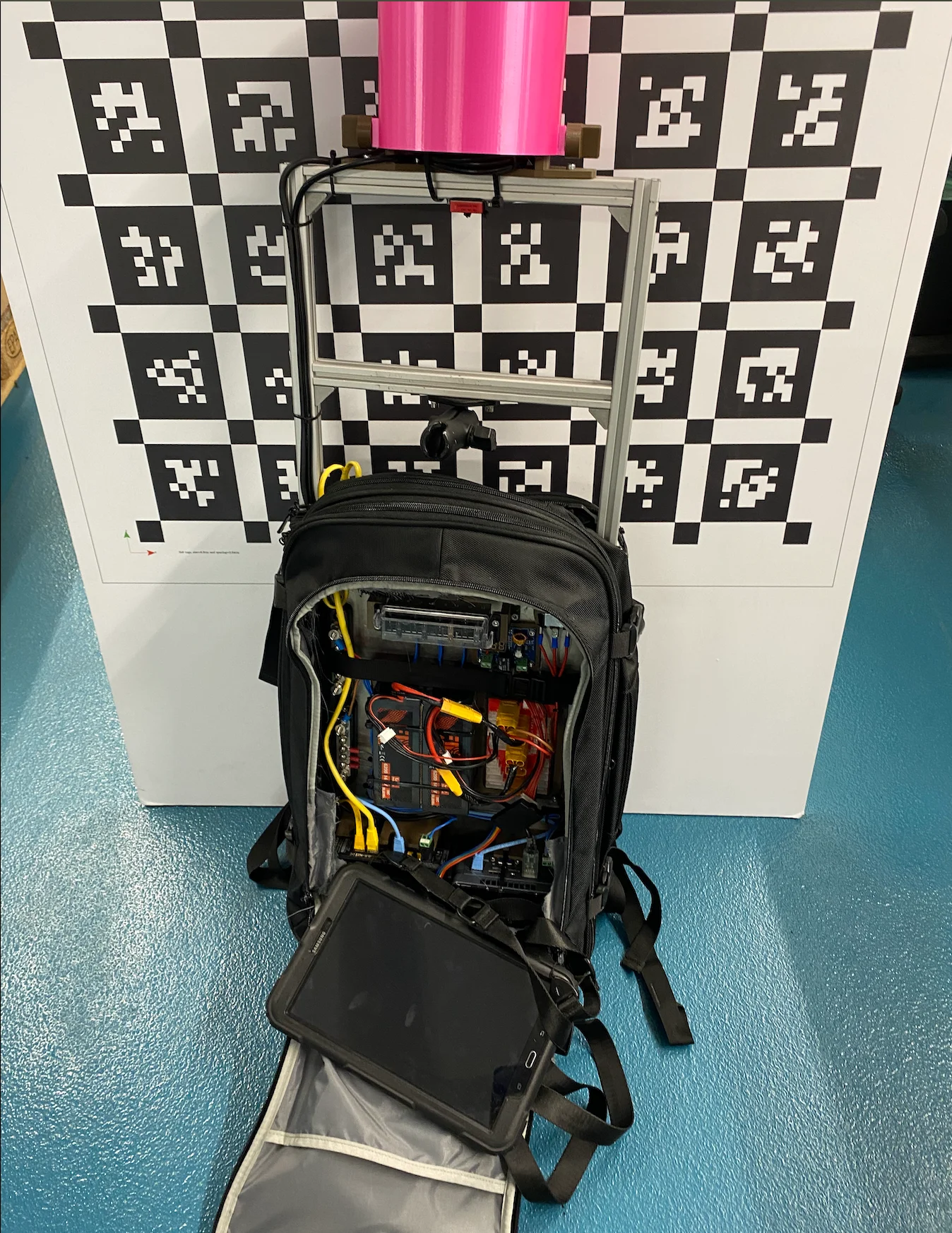
Quasimodo - 3D mapping backpack
Project Summary
I redesigned and prototyped a compact, wearable 3D-mapping unit—integrating LiDAR, IMU, compute, and power systems—to streamline environment mapping for an autonomous street-sweeper. The solution combined robust hardware assembly with ROS-based SLAM, secure data transport, and a simple user interface for rapid map generation.
Key Contributions
Hardware Design & Assembly
- Battery System: Selected and assembled a high-energy lithium-ion pack with integrated undervoltage and overcurrent protection to maximize runtime and safety in a backpack form factor.
- Mechanical Fixtures: Designed and 3D-printed a base plate with a foldable hinge mechanism, enabling the LiDAR/IMU module to pivot for compact stowage during transport.
- Wiring & Connectors: Engineered custom wiring harnesses and robust connectors to link sensors, battery, and compute units—ensuring reliability in field conditions.
Sensor & Compute Integration
- LiDAR & IMU: Mounted a RoboSense 3D LiDAR and IMU on the backpack frame, leveraging the rslidar_sdk for ROS integration to stream point clouds over ROS topics.
- Intel NUC: Deployed an Intel NUC mini-PC as the onboard "brain," chosen for its robust CPU performance and Linux compatibility in mobile robotics applications.
- Router & VPN: Configured an embedded router with WireGuard VPN to enable secure, remote tablet connections for live mapping and diagnostics.
Software & Mapping Workflow
- ROS & Cartographer: Implemented SLAM using Cartographer's ROS integration to fuse LiDAR/IMU data into real-time 3D maps, utilizing the demo-bag workflow for backpack setups.
- Mapping Interface: Developed a lightweight Python/C++ ROS node and a tablet-friendly UI to start/stop mapping sessions and visualize point clouds via RViz.
- Data Storage: Automated map uploads to a MinIO S3-compatible server for centralized map generation and archival.
Testing & Deployment
- Field Trials: Conducted on-site sweeper path mapping in urban environments, validating battery endurance, SLAM reliability, and sensor mounting stability.
- Optimization: Iterated on power-management thresholds and SLAM parameters to extend mapping time per charge and improve map fidelity.
Technologies & Tools
- Languages: C++, Python, ROS packages
- Compute & Networking: Intel NUC, Embedded Router, WireGuard VPN
- SLAM & Sensors: Cartographer ROS, RoboSense LiDAR (rslidar_sdk), IMU
- Storage & Backend: MinIO S3-compatible Object Storage
- Mechanical & Power: Fusion 360 (for base plate), Lithium-ion battery packs with protection
- UI & Visualization: ROS RViz, custom tablet interface (HTML/CSS/JavaScript)
Outcomes & Impact
- Delivered a 30% reduction in mapping setup time by consolidating hardware into a single backpack unit.
- Achieved continuous 3D mapping runs exceeding 2 hours on one battery pack, supporting extended street-sweeper deployments.
- Enabled secure remote monitoring, allowing operators to initiate mapping sessions from a tablet without tethered cables.